Hiking tracks

Nature trails, bicycle tracks, canoe or kayaking routes.


Viru bog trail

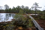
Viru bog trail is one of the m ost famous bog trails near Tallinn. It´s about 40 km on Peterburi maantee towards Narva. Then turn left to Loksa direction, few hundred meters and on trhe right side is a small parking place with map stand and DC.

Track starts from N 59.470907 E 25.637528.

Track is recorded in early winter time with high water, You can follow it exactly at any time. 

Iru city nature trail

Iru matkarada, Iru ÄmmIru trail is inside the city borders, but You can find pure nature and even animal activity here. This is unofficial track, so remember: no signs and no trails may be on the way. Beware of local land owners - track leads You to shore trail, what is officially free to pass for everyone, but some land owners are very angry about strangers. This didn´t happened to Us on our way, but You never know... all the track is publicly accessible by the law, some parts may change during the construction works near Iru Power Station, so follow the fences and signs.

Endla Nature Reserve

Endla Looduskaitseala, matkaradaEndla Nature Reserve is one oft the most famous bog areas in Estonia. The Endla Nature Reserve was established in 1985 to protect the best preserved central part of the mire system and karst springs of the southern slope of the Pandivere Upland. It´s necessary to register Your visit at Tooma, where Nature reserve center is locating. Call +372 77 63375.

This track starts from N58°52.5963' E026°16.3836' - this is parking place in front of Tooma nature reserve center.

Emajõe Suursoo bogtrail

Emajõe Suursoo, AhunapaluEmajõe Suursoo bog track is hard to reach, but is one of the wildest areas in Estonia including wetlands at Estonian bigger river Emajõgi delta on shores of Peipsi lake. This track ends away from starting point, so You have to walk twice this track - or use two cars for logistics to the end and back. This bog is good example of Estonian river wetlands.

Pics from this track will be added soon.
Google Map - track and waypoints.

Hiking tracks for nature travel in Estonia

GPS Tracks for Travellers

This page collects GPS Tracks of some hiking routes followed by GPS owners.
Just search Your interesting route from list from right menu here, look track on the map and then download it.

How to download? Click on the name of *.GPX file and select Save As... after that, open GPX-file with Your favourite GPS utility (for example, GPSU). Then, save Your tracks and data from GPS and upload new track to your GPS. If You wish, it´s good idea to merge Your selected hiking track with Your previous tracks and waypoints. Follow the track legend to visit waypoints marked on track. You can use downloaded .GPX file with Google Earth, what is good mapping program showing a track on map or on satellite image. Just open it in Google Earth.

Subscribe to Hiking tracks

We use cookies on our website to support technical features that enhance your user experience.

We also use analytics & advertising services. To opt-out click for more information.